![]()
Agricultural growers encounter various challenges with traditional soil sampling methods. These challenges include:
The solution is SoilOptix® , a unique, high-end top soil analysis technology that establishes the benchmark for precision and accuracy in agriculture; it's a value-added layer that integrates into the regular management choices farmers make for their fields.
“Now, we can define where the specific issues are in a field, being a nutrient or soil property and can now create a plan to address those issues. And it’s the only system that gives us a full texture profile across a field. We know sand, silt and clay are different. However, we could not measure them to this detail before. Now, we can use this in our Variable Rate program to fine tune where we put our fertilizer applications with more precision. Why sample the average when we can sample the variability?” (Trevor Thornton, CCA, P.Ag. Crop Care Consulting Ltd.- SoilOptix® Service Provider Since 2016).
The SoilOptix® process from in field collection to a final data layer involves a standard four step process in which the gamma radiation-based sensor data is combined with strategically located physical soil samples as calibration, providing with soil mapping results in high resolution top soil property layers. The survey data and subsequent lab analysis results of the soil samples are submitted to SoilOptix® data analysis team for processing to be completed. SoilOptix® results are accessible for providers and growers through the SoilOptix® customer data portal, where fields can be visually assessed or download spatial files such as a shapefile or csv which can be loaded into GIS specific programs/platforms. The resulting data from SoilOptix® can be used for multiple purposes including variable rate application of fertilizer or seed, precise management of water, or more informed practices around field scouting.
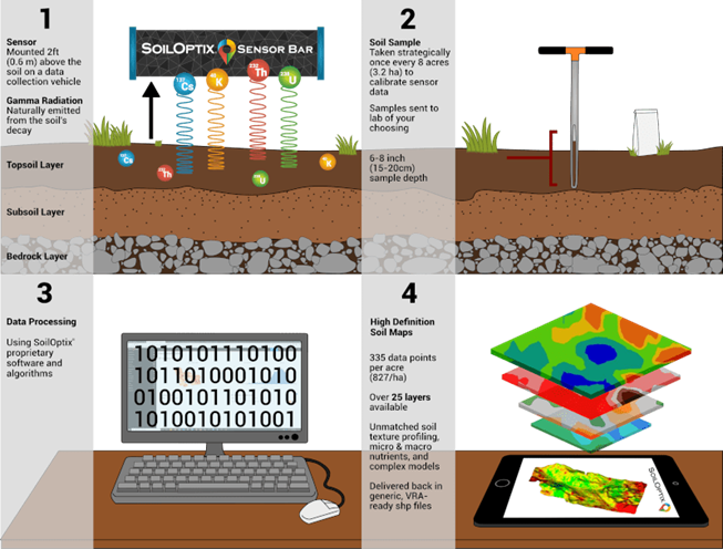
The figure below illustrates this four-step process where each is important to the resulting SoilOptix® high resolution soil data information.
|
Figure: SoilOptix® Step-By-Step Infographic (Source: SoilOptix.com, link: here) |
The use of gamma radiation in agriculture, previously limited to the geological mining sector, became the subject of research initiated in Europe in 2003.
In 2010, the technological opportunity presented by SoilOptix® was introduced, prompting Practical Precision Inc., founded in 2009, to explore its implementation in North America.
By 2013, Practical Precision brought the SoilOptix® technology to market, offering it as a service to growers in Ontario, Canada, after three years of dedicated research and development.
As of 2021, the company celebrates eight years of operation and provides services in over twelve countries, including Morocco. SoilOptix® continues to uphold its mission by expanding research and development efforts to address spatial measuring challenges in field soils.
For the European market, Syngenta Europe was established through an exclusive contract with Hutchinsons Crop Production Specialists, a UK partner. It is now the authorized supplier of SoilOptix® services for all 51 European nations. The operations, initially launched under the Interra Scan brand, are set to expand, beginning in Hungary, Poland, France, and Ukraine.
Phone: (+1) 519-902-7645
Website: https://soiloptix.com
Email: info@soiloptix.com
Facebook: https://www.facebook.com/SoilOptixInc/
LinkedIn: https://www.linkedin.com/company/soiloptix-inc/
Youtube: https://www.youtube.com/@soiloptix
Instagram: https://www.instagram.com/soiloptix/
Twitter: https://twitter.com/i/flow/login?redirect_after_login=%2FSoilOptix%2F
Irene Facchin (INI-Novation GmbH)

Funded by the European Union. Views and opinions expressed are however those of the author(s) only and do not necessarily reflect those of the European Union or the European Education and Culture Executive Agency (EACEA). Neither the European Union nor EACEA can be held responsible for them.
Project number: 2021-1-DE02-KA220-VET-000034651
All AgriSkills Intellectual Outputs are Open Educational Resources.
Creative Commons Attribution-Non-Commercial-Share-Alike 4.0 International License.
Google Play and the Google Play logo are trademarks of Google LLC.